Friday, September 17, 2021

Shoulder Season

The promise of fall color and a dramatic view of a spiky mountain summit towering over a pristine alpine lake drew me to hike to the top of Mount McCausland this last Thursday. The Smithbrook trail gains elevation through a series of switchbacks up the junction with the Pacific Crest Trail (after about 1.25 miles and 650 feet gain). After turning left, the PCT ambles south through the woodland and finally breaks open near Lake Valhalla.

The trail up to Mount McCausland is the first obvious right just after a first glimpse of the lake. There is no longer any cairn. Just go right and go up. The trail soon steepens and gains elevation rapidly. In the lower sections, there are braids of trails, all of which converge as you get higher. Some areas have big steps and the rock is loose but most of it is good trail. Poles help. After the ascent, the trail runs north along the ridgeline. About midway, the views are to the east and west and not panoramic due to the trees along the ridge.

The true summit hosts a metal summit register box that sits on a north-facing granite prow that drops off on three sides. Access is somewhat circuitous. One way is to stay to the right, on the east side, carefully crossing a section of steep rocks. Stay high and drop down to the trail and hike back up through the trees and skirt toward the summit blocks on a down-sloping dirt trail on the west side. Others may choose to go through the trees which is not as easy. The view to the north is crowned by an alarmingly snow-free Glacier Peak. And also, I could see wildfire smoke from the nearby Nason Ridge Fire.

Fall color and bourbon. Right? Yes! One small surprise was meeting up with a couple of young women and their dogs as I departed the summit. We talked about the circuitous route and I noticed one was carrying a full bottle of bourbon in her outside mesh pocket on her pack. Soon we were talking bourbon and she offered me some. I did not decline. She splashed a generous amount into an empty soft flask that I had in my pack. I took a pull once back at the trailhead and split the rest with my wife after dinner on the couch. Chattanooga Whiskey, a Tennessee bourbon made by her cousin. Very good! Another fine day in the mountains.

The big show was to the to the south, featuring the spiky peak of Lichtenberg Mountain and the azure blue Lake Valhalla. Mountain ash and huckleberries providing the dramatic, breathtaking fall color. The descent back to the PCT was spectacular.

I did take a 360 panorama at the southern flank of Mount McCausland, a view that captures the fall color arrayed before a vista with Lichtenberg Mountain and Lake Valhalla. And also, one at Lake Valhalla on a soggy day in 2016. The 360s are hosted at 360cities.net For best viewing click on the ‘Toggle Fullscreen’ icon in the panel in the upper right of the onscreen image. Then scroll to experience the immersive images.

Mount McCausland, Fall Color Vista: https://www.360cities.net/image/mount-mccausland-fall-color-vista-wenatchee-national-forest-wa-state

Lake Valhalla in the Mist: https://www.360cities.net/image/lake-valhalla-and-lichtenberg-mountain-central-cascades-wa-state

Wednesday, September 8, 2021

Sky Walking Granite

I have frequently hiked to the Kendall Katwalk via the Commonwealth Creek Trail. This last spring a journey of roots, rocks, snowfields, stream crossings, deadfall, brush, mud, and bugs. And yet, the air was fresh, the streams were talking, the trees were fragrant, the flowers out, and the views sublime. Simply some kind of wonderful! I love this hike!
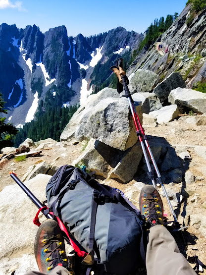
     The famed Kendall Katwalk is a stunning, jaw-dropping sky walk, probably the most arduous and expensive 450-foot section of path ever constructed. At only 4-feet wide, it traverses across a steep 50-degree rock cliff, with granite walls on the west side and a sheer unimpeded drop of 800 feet on the east. Surrounded by jagged Snoqualmie area peaks, the place demands your attention and begs you to stay.

     The Snoqualmie area section of the Pacific Crest Trail was created to be more “horse friendly” than the old Cascade Crest Trail that snakes up the Commonwealth Creek basin and precipitously drops over Red Pass as it travels north towards Canada. lmo Warren, the Idaho-based lead contractor for the PCT project, called it “the hardest piece of trail ever built.”

     Warren and his crew built a trail up to the ridge and set up camp at Gravel Lake in 1976, just north of the cliff face they would carve. Mules packed in 1,000 feet of steel cables and the 80-pound gas-powered drills that the workers would use as they rappelled down the cliff and bored holes for the dynamite to blast away large sections of the granite. It took them all summer. The result of their work is masterful, a perfect path that cuts straight across the cliff face. The exposure is unprotected as the crossing has no guard rail and yet it is less dangerous than sections of the narrow trail that lead up to it.

     Like Washington State fire lookout towers, the man-made Kendall Katwalk is a destination of distinction and many make the popular day 5.5-mile, 2,700 vertical foot hike to traverse the cliff, admire the views, have lunch, take photos, and return to the trailhead at Snoqualmie Pass. Some ascend Kendall Peak on their way to the Katwalk and others go further to Gravel Lake, to camp, and Alaska Mountain to summit. In the spring, sections of the trail, named Kendall gardens, are resplendent with wildflowers. The more I hike it, the more I enjoy the beauty of the experience. Best savored early in the day and mid-week.

I have taken several spherical panoramas along the Kendall Katwalk. You can experience being there on a clear day without the long hike in. You can even see the drill marks in the central section. The 360s are hosted at 360cities.net For best viewing click on the ‘Toggle Fullscreen’ icon in the panel in the upper right of the onscreen image. Then scroll to experience the immersive image.

Kendall Katwalk, South Shoulder: www.360cities.net/image/kendall-katwalk-south-shoulder-snoqualmie-national-forest-wa-state

Kendall Katwalk, Midway: www.360cities.net/image/kendall-katwalk-midway-snoqualmie-national-forest-wa-state

Kendall Katwalk, North Shoulder: https://www.360cities.net/image/kendall-katwalk-north-shoulder-snoqualmie-national-forest-wa-state

Sunday, September 5, 2021

Unfinished Business


It’s more common than we’d like to admit, not reaching a coveted alpine objective, mostly summits. For one reason or another, we turn back, driven by time, conditions, weather, or the fun meter pegging zero. And then, from the comfort of home, we think about it all over again. What if, and why not, we ask ourselves. And if we’re smart, some of those objectives are left behind as we pursue new, bright and shiny adventures. And sometimes not.

Last week I solo hiked the Rachel Lakes Trail up to the Lila Lakes – Alta Mountain trail split before turning back. I wanted to summit Alta but had run out the clock if I wanted to get home at a reasonable hour. Not happy with the time-consuming, sustained steep roots and rocks in the last mile of the trail before Rachel Lake I doubted I would return anytime soon. I was wrong. My unfinished business gnawed at me and I knew I had to resume my mountain quest.

Just nine days later, on Friday, joined with two friends who were up for an early start, we hit the tail at 6:50 am. The early miles were chilly but we warmed up and shed layers as the steep section started just past the trailside waterfall, about 2.85 miles. We paused at Rachel Lake to enjoy the view and continued up the rocky switchbacks up into the subalpine zone towards Alta Mountain. At about 0.4 miles from Rachel Lake, and 450 feet higher, we passed the Rampart Lakes – Lila Lake trail split taking the right towards Lila Lake. After another 0.3 miles and 100 feet of gain we encountered the Alta Mountain - Lila Lake trail split that is marked only with a small cairn.

We headed left up the steep loose dirt and rocks in the first section of the Alta Mountain trail. The trail continues up the ridgeline towards the summit of Alta Mountain through some alpine meadows that make one want to burst into song. And there are also rocky traverses around several false summits with some exposure that won’t be comfortable for everyone. After a bit more than a mile and another thousand feet of elevation gain, we finally reached the summit cairn. The views from the top were stupendous, probably some of the most spectacular in the Alpine Lakes Wilderness. Some wildfire haze but otherwise perfect, warm, and wind-free. We didn’t want to leave.

The descent from the rocky summit was fun, all the way to Rachel Lake. And then it turned into a tedious slog back to the trailhead. We finished suitably bushed but happy with the accomplishment. Sometimes it’s good to go back. We named the sensational hike: Roots, Rock, Reggae.


Just Ruck It!

The arrival of spring always signals the need to accelerate training for upcoming mountain exploits, both for simple one-day scrambles and...

Beers in the Stream